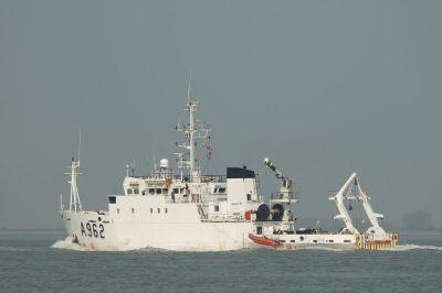
The “Belgica”, the Belgian navy ship converted into a research vessel, has now come to the Maritime Museum Ría de Bilbao and will remain docked at the quays of the Museum until Saturday, when they leave with the tide. Aboard the ship, and within the framework of cooperation between the Ministry of Economy of the Belgian Government and AZTI-Tecnalia, researchers from the Basque Technological Center will made a campaign using three multibeam echo sounder systems, technology used to know the depth and morphology of the seabed, off the coast of Lekeitio.
The information gathered will be integrated within the actions that the AZTI-Tecnalia Center performed on the project MESHAtlantic -funded by the Transnational Cooperation Programme Atlantic Area of the European Development Fund- that will be used to produce maps of marine habitats across Europe. In this area there is still a significant lack of information and mapping of seabed habitats is crucial for the proper implementation of European legislation, measures for resource management and biodiversity conservation.
Basic information with multiple uses
Depth, sound velocity, seabed echo, bathymetry, motion sensor, oil … All these terms are expressions that take part in the process of data collection and accurate representation of the seabed.
Knowledge of the characteristics of the funds is a basic information to understand and predict the distribution of habitats as well as goods and services to the marine ecosystem provides to humans. This information may also be used to infer what the effect of climate change on habitats and geomorphological processes in estuaries and beaches of our coasts. In addition, the legislation requires the morphology of the seabed and habitats in order to take the necessary measures for their protection and management.
Also, there is a demand of “marine topography” by multiple users (research, rescue and marine safety, maritime leisure enterprises engaged for marine research projects or to build infrastructure …).
We use cookies to improve your experience. By continuing to use our site, you accept our Cookies, Privacy Policy,Terms and Conditions. Close X